
There is no single number of feet from a road that is always public property.
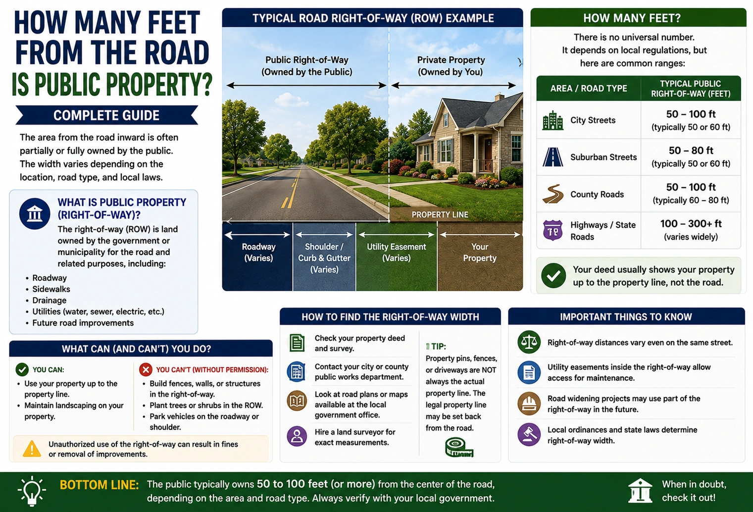
The public area beside a road is usually determined by the road’s right-of-way, and its width varies by location, road type, government agency, and recorded property documents. Examples of right-of-way widths include 40, 50, 60, 80, and 100 feet total, but these are not universal rules.
For example, if a road has a 60-foot right-of-way centered on the road, the right-of-way could extend about 30 feet from the centerline on each side.
However, the public right-of-way does not necessarily start at the edge of the pavement, and the government does not necessarily own every inch of land within a right-of-way. In some cases, the public has an easement while the adjacent owner retains underlying ownership.
Bottom line: You cannot accurately determine the public property boundary by simply measuring a fixed number of feet from the road. Check the deed, recorded plat, right-of-way documents, or a professional land survey.
How Many Feet From the Road Is Public Property?
The answer depends on the legal right-of-way width for that specific road.
A road right-of-way is commonly measured from one legal boundary to the other. Some local road standards specify minimum widths, while individual roads can have different recorded widths. For example, one county road standard specifies 50 feet for several road categories, while a Pennsylvania township lists residential road rights-of-way ranging from 50 to 60 feet and some larger roads at 80 to 120 feet.
Here is a simple illustration:
| Total Right-of-Way | Approx. Each Side From Centerline* |
|---|---|
| 30 feet | 15 feet |
| 40 feet | 20 feet |
| 50 feet | 25 feet |
| 60 feet | 30 feet |
| 66 feet | 33 feet |
| 80 feet | 40 feet |
| 100 feet | 50 feet |
*This assumes the right-of-way is evenly divided around the road centerline. Actual boundaries can be different.
Example
Suppose a road has a recorded right-of-way of 60 feet.
If it is centered around the road:
60 ÷ 2 = 30 feet
That means the right-of-way could extend approximately:
30 feet from the centerline on each side.
But that does not mean you can simply walk 30 feet from the center of the pavement and legally identify the boundary. The recorded right-of-way line controls.
What Is a Public Road Right-of-Way?
A road right-of-way is a legally established corridor used for a public road and related purposes.
It can be wider than the actual paved roadway.
Depending on the location, the right-of-way may include:
- Road pavement
- Shoulders
- Drainage ditches
- Sidewalks
- Utility areas
- Roadside signs
- Slopes
- Maintenance areas
- Future road expansion space
A public right-of-way may also be established in different ways. In some situations, the government owns the land. In others, the government or public has an easement or other legal right to use the land for transportation purposes.
This distinction is important because public use does not always mean public ownership.
Is the Edge of the Road the Property Line?
Not necessarily.
This is one of the most common property-boundary mistakes.
The pavement may end several feet before the legal right-of-way ends. A grassy strip, sidewalk, ditch, or shoulder may still be within the public right-of-way.
For example:
House → Lawn → Grass Strip → Sidewalk → Shoulder → Road
The area between the road and the house may look like part of the homeowner’s yard, but some of it could legally be part of the road right-of-way.
A township example shows why this matters: a 50-foot public right-of-way can include a paved section, curb, grassy area, and sidewalk, with the actual front property line located beyond the visible roadway features.
Simple Example
Imagine:
- Road pavement = 24 feet wide
- Right-of-way = 60 feet wide
- Right-of-way centered on road
The road uses only part of the legal corridor.
The remaining space can provide room for:
- Drainage
- Sidewalks
- Utilities
- Maintenance
- Landscaping
- Future improvements
So, the pavement edge is not automatically the property line.
How to Find the Exact Public Property Boundary
If you need to know exactly where public road property ends, follow these steps.
1. Check Your Property Deed
Your deed may contain information about:
- Property boundaries
- Road frontage
- Easements
- Rights-of-way
- Boundary descriptions
Some deeds describe a road as a boundary or reference a specific distance from a road centerline.
2. Find the Recorded Plat
A subdivision plat can be especially useful.
It may show:
- Lot lines
- Road boundaries
- Right-of-way widths
- Easements
- Road centerlines
- Dimensions
Recorded plats are often more useful than simply looking at the road from the property.
3. Check Government Property Records
Depending on the location, records may be maintained by:
- County assessor
- County recorder
- Land registry
- Public works department
- Highway department
- Transportation agency
- Municipal planning department
Look specifically for right-of-way maps, highway easements, road plans, and recorded plats.
4. Contact the Road Authority
The agency responsible for the road may have records showing the official right-of-way.
This can be particularly useful if the road has been widened or changed over time.
5. Hire a Land Surveyor
If the boundary is important, a professional land survey is the most reliable option.
This is especially important before:
- Building a fence
- Constructing a shed
- Building an addition
- Installing a driveway
- Planting permanent landscaping
- Buying or selling land
- Resolving a boundary dispute
A survey determines the legal boundary using records and physical evidence rather than simply measuring from the pavement.
Road Right-of-Way vs. Property Line vs. Setback
These three terms are often confused.
| Term | What It Means | Main Purpose |
| Property Line | Legal boundary of a parcel | Defines ownership |
| Right-of-Way | Legal corridor or right for road use | Transportation/access |
| Setback | Required distance for a structure or improvement | Controls development |
Property Line
This identifies where one parcel ends and another begins.
Right-of-Way
This identifies the area or legal rights associated with public road use.
Setback
This tells you how far a building or other improvement must be located from a specified boundary or right-of-way.
A setback does not automatically mean the land is public property.
For example, your property might begin 30 feet from a road, while local regulations require your house to be another 20 feet behind the property line.
That creates a development restriction, not another 20 feet of public ownership.
What Parts of the Roadside May Be Public?
The public right-of-way can include much more than pavement.
Road Shoulder
The shoulder may be within the right-of-way and can provide space for safety, maintenance, and emergency use.
Drainage Ditch
Ditches may be located within the road corridor to manage stormwater.
Sidewalk
A sidewalk may be within the public right-of-way even if it sits several feet away from the pavement.
Grass Strip
A grassy area between the road and sidewalk can also be part of the right-of-way.
Utility Area
Public rights-of-way may provide space for utility infrastructure and access.
The exact situation varies by jurisdiction and the documents establishing the road corridor. Road agencies commonly use right-of-way areas for drainage, utilities, maintenance, and future improvements.
Common Right-of-Way Width Examples
There is no universal width, but these examples help explain how the measurements work.
40-Foot Right-of-Way
If evenly divided:
40 ÷ 2 = 20 feet
Approximately 20 feet could extend from the centerline on each side.
50-Foot Right-of-Way
50 ÷ 2 = 25 feet
Approximately 25 feet from the centerline on each side.
A 50-foot right-of-way is used for some local road categories and residential streets.
60-Foot Right-of-Way
60 ÷ 2 = 30 feet
Approximately 30 feet from the centerline on each side.
80-Foot Right-of-Way
80 ÷ 2 = 40 feet
Approximately 40 feet from the centerline on each side.
100-Foot Right-of-Way
100 ÷ 2 = 50 feet
Approximately 50 feet from the centerline on each side.
Again, these calculations only illustrate a centered right-of-way. The actual legal boundary must be confirmed from property records.
Why Right-of-Way Can Be Wider Than the Road
A road needs more space than the lanes used by vehicles.
The additional land can provide room for:
- Drainage
- Road maintenance
- Utility lines
- Sidewalks
- Bike facilities
- Landscaping
- Slopes
- Future road improvements
For example, a township may have a 50-foot right-of-way even though the paved road itself is only about 24 feet wide. The remaining space can accommodate other transportation-related features.
That is why a homeowner may see a large grass area beside the road and incorrectly assume it is entirely private yard space.
Common Mistakes to Avoid
Mistake #1: Assuming 10 or 20 Feet Is Always Public
There is no universal 10-foot or 20-foot rule.
The right-of-way can be wider or narrower depending on the road.
Mistake #2: Measuring From the Pavement
The pavement is not necessarily the legal reference point.
The right-of-way may extend beyond the pavement.
Mistake #3: Assuming the Grass Is Private
Grass between the road and a house may be inside the right-of-way.
Mistake #4: Confusing Setback With Public Property
A building setback does not automatically change ownership.
Mistake #5: Relying Only on an Online Map
Parcel maps are useful for research but may not show every easement, dedication, or legal right-of-way.
Mistake #6: Building Before Checking
Installing a fence or structure before confirming the boundary can create expensive problems later.
What to Do Before Building Near a Road
If you are planning an improvement near a road, use this checklist:
- Check your property deed.
- Find the recorded plat.
- Identify the road right-of-way.
- Check for easements.
- Review local setback requirements.
- Contact the road authority if necessary.
- Confirm the property line.
- Hire a surveyor if the boundary is uncertain.
- Obtain any required permits before construction.
This is especially important for fences, sheds, garages, driveways, retaining walls, and permanent landscaping.
Practical Example: Finding the Boundary
Suppose a homeowner has a property beside a public road.
The pavement ends 12 feet from the homeowner’s fence.
The homeowner assumes those 12 feet belong to the private property.
However, the recorded right-of-way is 60 feet wide, centered on the road.
If the road is positioned in the center of the right-of-way, the legal boundary may be approximately 30 feet from the centerline.
Therefore, the visible pavement edge does not necessarily tell the homeowner where the legal property boundary is.
The correct answer comes from the recorded right-of-way—not from looking at where the asphalt ends.
Why the Exact Location Matters
Knowing the right-of-way boundary can prevent problems with:
Fences
A fence placed inside a public right-of-way may have to be moved.
Driveways
Driveway entrances may require approval from the road authority.
Trees
Trees or landscaping may interfere with visibility, drainage, utilities, or maintenance.
Buildings
A shed, garage, addition, or other structure may need to meet both property-line and road setbacks.
Drainage
Blocking a roadside ditch can affect water flow and may violate local requirements.
So, even if a strip of land looks unused, do not assume you can permanently occupy it.
9. FAQs
1. How many feet from the road is public property?
There is no standard number that applies everywhere. The public right-of-way may be 40, 50, 60, 80, 100 feet, or another width depending on the specific road and its legal records.
2. Is the land between my house and the road public?
Not necessarily. Some of it may be private property, while some may fall within a public right-of-way or easement. Check the deed, plat, and right-of-way records.
3. Is the edge of the pavement the property line?
Usually, you should not assume this. A public right-of-way can extend beyond the pavement to include shoulders, drainage areas, sidewalks, and other roadside space.
4. How far does a 60-foot road right-of-way extend?
If the 60-foot right-of-way is centered on the road, it would generally be 30 feet from the centerline on each side. The actual legal boundary can differ if the right-of-way is not centered.
5. How can I find my exact property line near a road?
Check your deed, recorded plat, official property records, and right-of-way documents. For an exact boundary, especially before construction, hire a qualified land surveyor.
10. Conclusion
So, how many feet from the road is public property? There is no universal number.
The important measurement is the road’s legally established right-of-way. Depending on the location, a road corridor may be 40, 50, 60, 80, 100 feet or more in total width. However, these are examples—not a rule that applies to every property.
Remember these key points:
- The edge of the pavement is not necessarily the property line.
- The road right-of-way can extend into the grass, shoulder, ditch, or sidewalk area.
- A right-of-way does not always mean the government owns the underlying land.
- A setback is different from a right-of-way.
- The deed, plat, official records, and survey provide the best evidence of the boundary.
If you are planning to build, fence, landscape, or modify a driveway near a public road, verify the right-of-way before starting work.
The safest answer to how many feet from the road is public property is therefore: it depends on the specific road and its legally recorded right-of-way—you cannot determine it accurately from a standard number of feet alone.
Discover More Articles
Signal Before Turning: How Many Feet Before a Turn?